– Alexander Königs
Once the order has been placed, a rough sketch of the later depiction is created. It will provide information about the exact area boundaries, viewing angle, format and type of perspective. The map is first created with the help of computer-aided digital terrain models. This preliminary version already provides a good impression of the later appearance of the panoramic map.
Close co-operation with the client is particularly beneficial in this development phase in order to optimally integrate the client's ideas and wishes into the design of the map. This is where your ideas are combined with my recommendations. The most important characteristics of the later appearance are defined here
Once the customer is completely satisfied with the basic version created in this way, the actual final artwork for the panoramic map is produced by hand. I keep my customers informed about the current status of the map by means of images during all the relevant work steps. This means that the colouring of the map, for example, can be changed at any time. Important details can be added or changed at any time. Consultation with you thus accompanies the entire work process.
In the final step, the layout, text positions and titles are finalised. This is also done in close consultation with the client. For example, scenic or cultural features or even your logo can be integrated. New thematic focuses can be added at any time in additional layers: While the background image remains the same, all content can be changed or incorporated in subsequent editions (e.g. hiking and cycling trails, ski slopes, lifts, viewpoints, places of interest, etc.).
All maps leave the studio only after the customer is completely satisfied. Responding to your wishes and suggestions and incorporating them into your panoramic map with the highest level of quality is a matter of course. As early as the planning phase, I will be happy to advise you on the best way to present your panorama. My customers always receive the high-resolution, print-ready data set of their map, including text typesetting and layout - simply ‘ready for print’.
I am looking forward to working with you and will be happy to make you a personalised offer and provide you with further details on the way to a panoramic map of your region.
Would you like to present your region in an appealing way and at the same time convey all the geographical information? Go beyond the purely topographical content of a ‘map’ and present your region with its unique charm and character!

born in 1966, comes from Rhoden in Germany and now lives in Diemelstadt/Germany.
His studies in geography and art at the University of Paderborn provided him with the ideal conditions for his later panorama work. His long-standing and close friendship with the well-known Innsbruck panorama painter Prof. Heinrich C. Berann, whom Alexander Königs met at the age of 16, offered him further opportunities and also laid the foundation for his current artistic work. This includes both graphic panorama works and fine art.
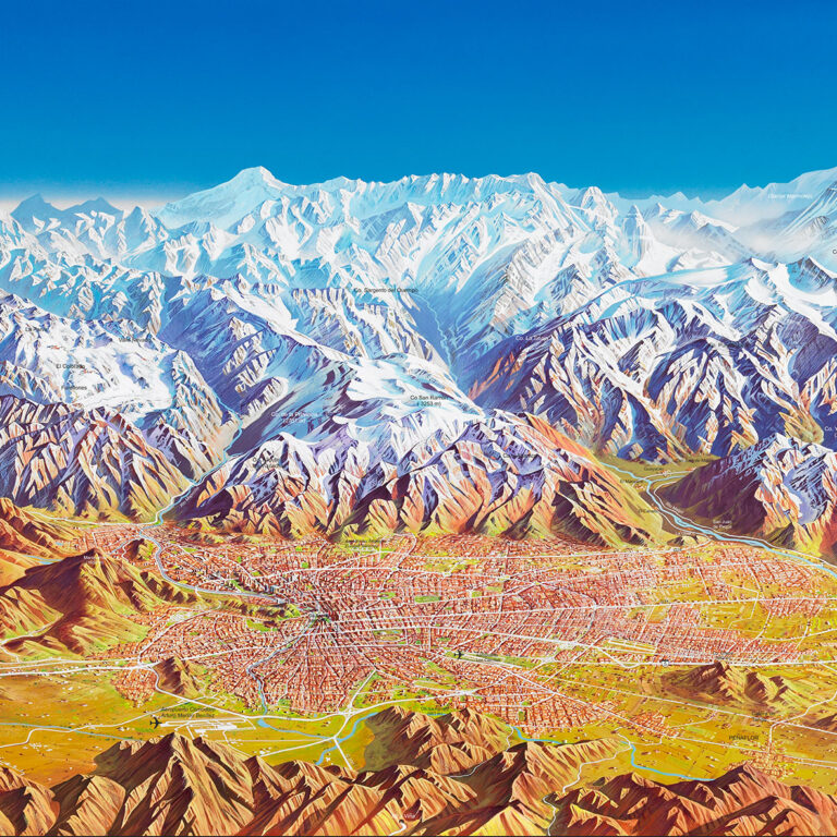
Alexander Königs enjoys an international reputation as a panorama painter after more than 25 years of studio work. He spent 15 years painting panoramas in South America. With his panoramic maps he serves a clientele from Japan to Australia and from the Grand Canyon to the Arabian Desert. Most recently he worked for the Sultanate of Oman, where he produced a map of the Muscat metropolitan area for the World Habitat Society.
In addition to panorama painting, he pursues his passion for classical painting and music in his Paderborn studio and is also enjoying increasing popularity in his home country as a musician and composer
Altastenberg Liftgesellschaft
Andes Expediciones, Bolivia
Andina del Sud, Chile
Aqua Motion, Chile
Argentina Tourist Board
Australian Tourist Board
Bad Wildungen Stadtmarketing
Bolivia Tourist Promotion Board
Chilean Tourist Board
CONAF (Corporación Nacional Forestal), Chile
Condor Maps, Chile
Ecker Yachting, Austria
Feldbergbahnen GmbH
Feldberg Schwarzwald
Flussparadies Franken e.V.
Fränkisches Saaletal
Fremdenverkehrsverband Erzgebirge
Füssen Tourismus und Marketing
Galli Verlag
GEO Center, Touristik & Medien
Grand Canyon Nationalpark, USA
Grimm Heimat Nordhessen
Hema Maps, Australien
Herder-Institut für historische Ostmitteleuropaforschung
Huber Medi
INTEWO Tourism – Oman and Ethiopia
INTERKART
Kötztinger Land
Kommunale Allianz Fränkisches Saaletal
Kreis Lippe
Kreis Paderborn
Kreis Soest
Land Hessen
Landkreis Waldeck-Frankenberg
Liftgesellschaft Altastenberg
Luxemburg Fremdenverkehrsamt
Märkischer Kreis
Ministry of Tourism, Oman
Naturpark Frankenwald
Naturpark Hohe Mark Münsterland
Naturpark Schwäbisch-Fränkischer Wald
Naturpark Spessart
Naturpark Stromberg-Heuchelberg
Office Régional du Tourisme des Ardennes Luxembourgeoise
Ostbayern Tourismus Marketing GmbH
Projekt ARD
Regionalmanagement Mittelhessen
Region Sundern-Allendorf
Rhein – Sieg – Kreis
SERNATUR, Servicio Nacional de Turismo, Chile
Sintfeld – Höhenweg
Sparkasse Grünberg
Sparkasse Paderborn
Stadt Bad Kötzting
Stadt Diemelstadt
Stadtmarketing Bad Wildungen
Stadtmarketing Willingen Sauerland
Sultanat of Oman
TEIKOKU-SHOIN CO. LTD, Japan
Tirolwerbung, Österreich
Tourismusgemeinschaft Frankenland
Tourismusverein Paderborner Land
Tourismusverein Traben-Trarbach, Mosel
Touristikverband Siegerland-Wittgenstein e.V.
Tourismusverband Wipptal, Österreich
Tourismusverband Ostbayern e.V.
Tourist-Info Roding
True-Design Werbeagentur
Urlaubsland Furth im Walde
Verwaltungsgemeinschaft „Salzbrücke“
Verwaltungsgemeinschaft „Burgebrach“
Wanderregion Sundern-Allendorf
Werbegemeinschaft Willingen
Westermann Schulbuchverlag
WHS – World Habitat Society
Wintersportarena Sauerland
Wintersportarena Sauerland – Siegerland Wittgenstein e.V.
Wurmberg- Seilbahngesellschaft, Harz